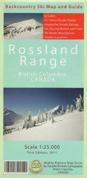
Mighty Bighorn Maps Books Rossland Range Map
Original price was: $16.95.$12.54Current price is: $12.54.
- Shop with confidence, enjoy free returns.
- Free Shipping, No Compromise on Quality
- Friendly, efficient service, always online.
- Fast reliable delivery options

Rossland Range Map
New map by Mighty Bighorn Maps. The Rossland Range backcountry ski map and guide consists of one 1:25,000 topographic maps and 32 colour photographs with route descriptions on the reverse side. The total map size is 33″x27″ unfolded. These high-quality maps and guides are printed on durable polypropylene paper that is both waterproof and tearproof and can withstand the most extreme elements. Each map is double-sided and contains essential information for backcountry snowboarders/skiers including: oblique-angle colour photographs, route descriptions and paths, avalanche terrain exposure scale ratings, backcountry shelter locations, etc
| Option one | Rossland Range Map |
|---|
Be the first to review “Mighty Bighorn Maps Books Rossland Range Map”
Related products
Activities

Activities
Activities
Activities

Activities

Activities
Reviews
There are no reviews yet.